


iMaps for Google - GPS Navigation app for iPhone and iPad
Developer: Panteleimon Lavrov
First release : 25 May 2015
App size: 0 Bytes
Now you can take advantage of a more convenient and versatile way to enjoy new places. Travel and discover the world no guide will ever be able to show you. You can do it all from your favorite iPhone, iPad, iPod...
Your small, but not insignificant guidebook to the big world, Maps - Google Maps with Offline Viewing, Directions, Street View, Places, Search, GPS Services, Ruler app will save you from getting lost or missing something really interesting!
General information:
=============
Current location button
Compass is located at the upper left corner of the map, pointing to the North. It can be also tapped to reset map rotation.
In a tracking mode, the compass points to the North.
Quickly switch between road, satellite, hybrid and terrain maps.
The map is automatically saved for offline access.
Find a location by address, name, zip code, and coordinates.
Find a location using addresses from your Contact list.
Bookmark your favorite places for quick access.
Settings for different map types, control types (pan, tilt, zoom, paging).
Get access to 3D road maps of major cities of the world
Get an overview of real-time traffic in major cities of the world
Help page
Pin Menu:
=============
Touch and hold to place the pin anywhere on the map
Easy access to the pin menu, with a label for indicating "From-To" route direction
Bookmark terrain or locations directly from the pin menu
Search places of interest from the pin menu
Get access to street view via pin menu
Ruler mode:
==================
Ruler mode will help you find the exact distance between multiple points
Easily add and remove rulers points
The distance is shown in British and metric system of measurement ( select from the Settings page)
Colored line between points
Direction Mode:
==================
Get step-by-step directions when driving a car, riding a bicycle or walking.
Add up to 8 destination points.
Information table and easy navigation between route directions, steps, and markers.
Ability to choose alternative routes (if available) if this function has been enabled in the setting page.
GPS route mode, with auto map setting.
Route settings allow to avoid toll charges and/or highways.
Route settings allow to select optimal directions.
Route settings allow to choose British or metric system of measurement.
Turn the origin point into the destination point and the other way round.
Easily add, delete, or clear text in the Destination Point field
Search Area mode:
=======================
Select areas of interest within a certain radius
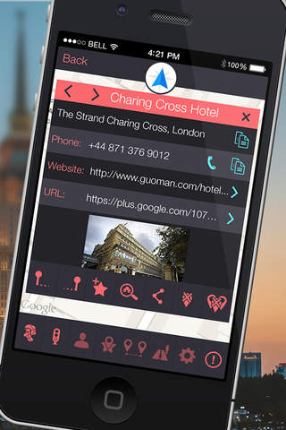
Detailed location information, including name, address, official website, phone number, hours of operation, photo of the location, and also reviews visible in search results.
Copy addresses and phone numbers to clipboard, dial direct phone numbers, go to the website or Google + page.
Awesome photo browser for viewing location photos, saving photos, sending photos via email or copying to clipboard.
Get access to street view (if available).
Get access to hours of operation and reviews from Google users.
"From-To" button to view the route between two locations.
Bookmark important or favorite locations for quick access.
Share locations via Facebook, Twitter, E-mail, Skype, SMS or by copying the link.
Place the Area Search button within a specified radius from a certain point.
Easy navigation between locations, ability to delete one or all locations.
Street Observer mode:
=======================
Street view from a normal map.
Street view with panorama street coverage.
Street view with traffic coverage.
Street view with transit information.
Street view with weather information.